
Page 276 - The Guide To Sarawak
P. 276
274 RIVERS, LAKES & THE SEA
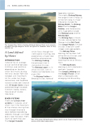
The Sarawak River Delta in Kuching Wetlands National Park. Such snake-like meanders through mangrove forests are typical for Sarawak’s rivers as they near the sea.
legendary warriors.
The mighty Batang Rejang, the longest river in Malaysia at 562.5km long. Its major tributaries include the Batang Baleh, the Batang Balui and the Sungai Katibas, and the branches of its huge delta include
the Batang Lassa and the Batang Igan.
The Batang Oya in Mukah Division, connected to the Rejang via the Kut Canal. The Sungai Mukah in Mukah Division, lined with water villages and sago gardens.
The Batang Tatau, draining the southern half of the Bintulu Division, and The Batang Kemena, reaching the sea at Bintulu town.
The Batang Baram, draining a vast hinterland in northern Sarawak.
The Sungai Limbang and the Sungai Trusan, which drain Limbang division, emerging into Brunei Bay.
A Land defined by Water
INTRODUCTION
Sarawak has an average annual rainfall of between 3,300mm and 4,600mm depending on location, which falls mainly during the rainy season from late October until mid-March. All this water has to go somewhere, and therefore nature has blessed Sarawak with 55 major rivers whose combined length exceeds 5,000km, fed by literally thousands of smaller tributaries.
RIVER SYSTEMS
There are 12 main river systems in Sarawak, all of which rise in the mountains of the interior, carving their way through limestone rocks before meandering sedately through vast flood plains near the coast. From south to north they are; The Sungai Sarawak,
which flows through the state capital, Kuching, and experiences a major tidal backflow phenomenon. The Batang Sadong,
the principal river in Samarahan Division.
The Batang Lupar, in Sri Aman Division, with its impressive tidal bore (see page 148).
The Batang Saribas in Betong Division, home of
One of the many stilt-built water-villages which can be found along the lower reaches of the state’s major rivers.
